Satellite analysis reveals glacier collapse triggered Nepal's deadly floods
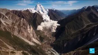
New satellite imagery and video analysis indicate that a glacier collapse near the Chinese border set off a debris flow traveling at up to 150 km/h, devastating communities across more than 80 kilometers. Scientists are still reconstructing the exact sequence, while authorities warn that an overflowing upstream lake could cause further flooding.
The catastrophic event originated when a glacier segment near the Tibetan frontier gave way, unleashing a torrent of ice, rock, and sediment that accelerated to roughly 150 kilometers per hour. This debris flow carved a destructive path exceeding 80 kilometers, overwhelming settlements and infrastructure in its trajectory. Investigators are currently analyzing satellite footage and eyewitness video to establish the precise chain of causation, though a complete reconstruction remains underway.
Compounding the immediate crisis, officials report that a new lake formed by the collapse has begun spilling over its banks, raising the specter of additional inundation. The disaster has prompted a multinational response, with neighboring countries dispatching aid and rescue personnel. Search operations continue for more than 1,300 individuals still unaccounted for, while humanitarian organizations describe entire villages as having been completely swept away.
This disaster may reshape how Himalayan nations assess glacial hazards, as warming temperatures increase the likelihood of similar collapses. Local communities face prolonged displacement and economic disruption, while the overflowing lake threatens downstream populations with secondary flooding. The high number of missing persons could strain Nepal's rescue capacity and international aid networks. Long-term, this event may influence infrastructure planning and early-warning systems across the region, though such adaptations would require substantial investment and cross-border cooperation.