Sensor Fusion Tool Helps Cities Manage Intersections More Safely and Efficiently
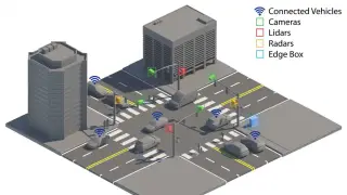
Researchers at the National Laboratory of the Rockies have developed a system that fuses data from cameras, lidar, radar, and vehicle sensors to give intersections real-time awareness. The tool is designed to cut crash risks and improve traffic flow, since intersections contribute to about a quarter of U.S. traffic fatalities and half of all injuries. Better signal timing could reduce delays by 15–40% and fuel use by up to 10%, according to federal estimates.
The IPC-Fusion toolkit merges multiple sensing modalities—cameras, lidar, radar, and connected-vehicle transmissions—into a single digital twin of intersection activity, eliminating blind spots that single-sensor systems miss. This infrastructure-based cooperative perception approach allows traffic signals to respond dynamically to real-time conditions rather than relying on fixed timing patterns.
Federal data cited in the research indicates that optimized signal timing could cut intersection delays by 15–40 percent and reduce fuel consumption by up to 10 percent. With intersections linked to roughly one-quarter of U.S. traffic fatalities and half of all injuries, the system targets both safety and efficiency gains. NLR is currently negotiating licensing with a major traffic solutions provider following successful validation trials.
This technology could meaningfully reshape urban mobility by reducing the roughly 40,000 annual U.S. traffic fatalities and billions in congestion-related losses. Municipalities adopting such systems may see safer crossings for pedestrians and cyclists, while drivers could experience shorter wait times and lower fuel costs. However, deployment costs, infrastructure upgrades, and data-privacy concerns may slow adoption, particularly in smaller cities with limited transportation budgets.