Satellite captures emerald lakes formed by record rainfall in Australia
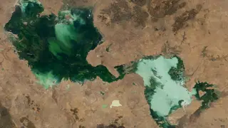
A 2024 satellite image shows several temporary lakes in Australia's Northern Territory merging into a single bright green water body after two years of exceptionally heavy rain. The lakes, typically dry, appear vividly colored in the photo. This event underscores how extreme precipitation can reshape the region's hydrology.
The satellite imagery, captured in 2024, reveals a striking transformation across the Northern Territory where normally arid lake beds swelled into a single vivid green expanse. This coloration stems from the sudden proliferation of algae and aquatic vegetation responding to the influx of freshwater. The region's ephemeral lakes are adapted to long dry spells, yet two consecutive years of exceptional rainfall overwhelmed their usual cycles.
Such dramatic hydrological shifts demonstrate how satellite monitoring provides scientists with a crucial vantage point for tracking landscape-scale changes. Remote sensing allows researchers to observe how extreme weather events alter drainage patterns and water distribution across vast, sparsely populated terrain. These observations help build a clearer picture of how climate variability is reshaping Australia's interior ecosystems.
This imagery could help scientists and land managers better understand how extreme precipitation events are altering arid-region hydrology, potentially informing water resource planning and ecosystem monitoring. Communities and agricultural operations in northern Australia may need to adapt to shifting flood and drought patterns. The striking visual also serves as a public reminder of climate volatility, possibly encouraging broader discussion about environmental resilience in regions traditionally defined by water scarcity.