Floating island's 30-kilometer drift across a Canadian reservoir explained
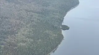
A large, tree-covered landmass unexpectedly appeared in British Columbia's Williston Lake this summer, then vanished and later resurfaced more than 30 kilometers away. Satellite imagery confirmed its existence, and officials determined it was a chunk of shoreline that broke free due to record-high water levels and strong winds. Such floating vegetated islands are rare but can occur in large reservoirs when water levels rise significantly.
The island’s movement was tracked through satellite imagery on specific dates—first confirmed on July 21, then missing by August 5, and relocated against the shore on August 15. BC Hydro’s Bob Gammer attributed the event to record-high reservoir levels lifting shoreline material that had been lodged in sheltered bays. The landmass, roughly the size of two football fields, remains intact and currently rests against the shoreline, though its future position is uncertain.
Floating vegetated islands are documented globally, particularly in wetlands, with Wisconsin’s Forty Acre Bog serving as a notable example of a detached landmass drifting on a lake surface. In Williston Lake, shallow-rooted trees and strong winds combined with elevated water to free the chunk. Such occurrences, while rare at this scale, highlight how large artificial reservoirs can produce dynamic, unexpected ecological phenomena when water levels fluctuate dramatically.
This event could reshape public understanding of reservoir management and climate-related water level changes. Communities and authorities relying on Williston Lake for hydroelectric power may need to monitor shoreline stability more closely, as similar breakaways could affect navigation, infrastructure, or local ecosystems. The island’s visibility also offers a tangible example of how rising water levels—potentially linked to broader climate patterns—can alter landscapes in ways that surprise both officials and residents, prompting renewed attention to environmental monitoring in managed waterways.