Pacific Storm Activity Soars While Atlantic Remains Unusually Calm, El Niño Explains Divide
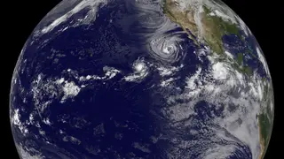
The Pacific has experienced multiple hurricanes near Hawaii this season, while the Atlantic has yet to see its first hurricane. Meteorologists attribute this stark contrast to a strong El Niño, which typically suppresses Atlantic storm formation while enhancing conditions in the eastern and central Pacific. If the Atlantic remains quiet past September 12, it would mark the latest first hurricane on record since 1966.
Hawaii typically escapes major cyclone activity due to strong trade winds and cooler surrounding waters, with only six storms passing within 50 miles over 75 years. Direct hits are even rarer, occurring just twice—Hurricane Dot in 1959 and Iniki in 1992. This season, however, brought Fausto, Lala, Moke, and Lowell near the islands.
The stark divide stems from a powerful El Niño, which warms Pacific waters up to 20 degrees north. This warmth, combined with unusually low vertical wind shear, fuels Pacific storms. Conversely, high shear in the Atlantic creates hostile conditions, causing systems like Tropical Storm Dolly to weaken rapidly.
The active Pacific season could heighten risks for Hawaiian residents and maritime operations, straining local emergency resources. Conversely, the Atlantic's quiet start may foster complacency among coastal communities, even though late-season hurricanes remain possible. This stark divide could also influence insurance pricing and disaster preparedness budgets, as forecasters and officials must adapt to shifting regional threat levels.