UN Vote on Map Projections Highlights Africa's True Size, With US as Holdout
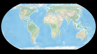
The United Nations voted to recommend that mapmakers correct distortions that understate Africa's size, with the United States as the only dissenting voice. The article argues that such cartographic changes reflect deeper perceptions about the continent. It suggests Africa offers solutions to Western problems.
The article references the Mercator projection, a standard classroom map that severely distorts landmass sizes, making equatorial and southern regions appear smaller than their true area. The UN's recommendation, opposed only by the US, points to alternative representations like the 2018 "Equal Earth" projection, which displays continents in accurate proportion. This cartographic shift carries symbolic weight beyond mere geography.
The piece connects the vote to Africa's rapidly growing demographic significance, noting that Western politicians remain largely reactive—Europe focuses on restricting migration, while the Trump administration has pursued deportation policies and reportedly used derogatory language about the continent. The author suggests these responses will eventually yield to recognition of Africa's increasing global importance.
This vote could influence how educational materials and public discourse frame Africa's global standing, potentially reshaping perceptions among students and policymakers alike. If adopted widely, accurate maps may foster greater awareness of the continent's demographic and economic weight, encouraging more substantive diplomatic engagement. The US holdout may signal continued resistance to symbolic recognition, but could also isolate Washington as other nations embrace the change. Ultimately, such cartographic corrections may subtly shift international priorities toward African partnerships.