High-resolution 3D map of Los Angeles basin pinpoints earthquake shaking hotspots
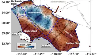
A new three-dimensional map of the Los Angeles basin reveals where deep sediment layers are likely to amplify ground motion during a major earthquake. The detailed subsurface imaging could help officials identify neighborhoods most vulnerable to the anticipated 'Big One' and inform building codes and emergency response plans. Variations in sediment thickness across the basin are key to predicting how seismic waves will behave.
The new subsurface imaging maps sediment thickness variations across the Los Angeles basin, a factor that strongly influences how seismic waves travel and intensify. Deep, soft deposits can trap and prolong shaking, while harder rock transmits energy differently. Because sediment depth changes sharply across neighborhoods, two areas close together may experience very different ground motion during the same earthquake.
This type of geological modeling is central to seismic hazard assessment. By identifying where amplification is most likely, engineers and planners can prioritize retrofitting older buildings, strengthen critical infrastructure, and refine emergency response routes. The map represents an advance in translating geological data into practical risk reduction for a densely populated region anticipating a major rupture.
This map could meaningfully shape how Los Angeles prepares for a large earthquake. Residents in neighborhoods identified as shaking hotspots may face higher insurance costs or stricter retrofit requirements, while officials could use the data to allocate resources and emergency services more effectively. The findings may also influence future building codes, potentially raising construction standards in vulnerable zones. However, the practical impact depends on whether policymakers translate the science into enforceable regulations and whether the public responds to updated risk assessments with preparedness measures.