Alaska capital gains early warning system for glacier-driven floods
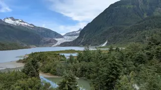
Juneau residents have faced repeated flooding from meltwater and rain near the Mendenhall Glacier, with record river levels in 2023, 2024, and 2025. A new online dashboard launched in 2025 translates glacier and hydrology data into practical forecasts, giving residents and officials more time to prepare or evacuate. The tool is seen as a model for communities dealing with recurring climate-related disasters.
The floods stem from a natural process: each summer, meltwater and rain accumulate in a basin beside the Mendenhall Glacier, which acts as a dam until pressure triggers a sudden release downstream. Juneau's geography compounds the risk — the state capital is reachable only by air or sea, and homes sit directly in the flood path.
Residents have responded with individual and collective measures. Some have dug moats, others have elevated their houses several feet, and the city has erected about six miles of barriers along the river. The new dashboard, launched in 2025, converts glacier and hydrology data into practical forecasts, giving people time to secure belongings or evacuate before waters rise.
This early warning system could reshape how communities worldwide approach recurring climate disasters. Juneau residents — who have endured three record floods in as many years — may gain greater confidence and safety, while officials gain a template for translating complex scientific data into actionable guidance. Other glacier-adjacent regions and flood-prone cities could adopt similar models, potentially reducing property damage, displacement, and trauma. However, the tool's effectiveness may depend on public trust, consistent funding, and whether forecasts arrive early enough to matter in fast-moving emergencies.