Four early indicators may signal a tropical cyclone is preparing to rapidly intensify
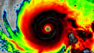
Analysis of nearly three decades of aircraft observations has uncovered four structural and environmental factors that help a tilted tropical cyclone straighten its circulation and become capable of rapid intensification. The findings may allow forecasters to recognize strengthening potential earlier, giving communities more time to prepare.
The research draws on 1,510 radar analyses from NOAA Hurricane Hunter aircraft, compiled in a database called TC-RADAR. These flights gathered observations over nearly three decades, allowing scientists to compare storms that successfully straightened their tilted circulations against those that did not. The four favorable indicators include a compact low-level circulation, a tilt positioned favorably relative to wind shear, strong rising air near the lower center, and an environment with warm water, moisture, and weak mid-level winds.
Vertical alignment matters because a storm's rotating centers at different levels must line up before substantial intensification can occur. Strong upper-level winds can push the top of the circulation away from the surface center, keeping the storm disorganized. When these centers realign, the storm becomes capable of rapid strengthening.
The findings could give forecasters a head start in recognizing when a seemingly disorganized storm is primed to strengthen. Coastal communities and emergency managers may gain additional time for evacuation decisions and other preparations, which could reduce risk to life and property. Because rapidly intensifying storms often leave little response time, earlier warnings may be especially valuable for vulnerable coastal regions.