Ancient cave collapses linked to Australia's puzzling surface trenches
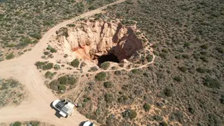
New research indicates that long, shallow trenches on Australia's Nullarbor Plain are surface scars left by massive ancient cave systems that collapsed deep underground. These trenches, which run north-south and can exceed 12 miles in length, lack the connected streams typical of water-eroded valleys. The study's authors propose that the collapse of these caves created the distinctive surface features.
The trenches align with known cave systems accessible via sinkholes, and their north-south orientation matches groundwater flow toward the coast during the Oligocene epoch. Electrical resistivity imaging revealed canyon-like structures descending over 130 feet, filled with layered sediment—sand near the top, finer silt and clay below. This suggests the caves collapsed gradually, leaving surface depressions that later accumulated windblown and waterborne material. The abrupt start and end of each trench, unlike typical river valleys, supports a collapse origin rather than erosion.
This research could reshape how geologists interpret arid landscapes elsewhere, where similar surface features might be misread as ancient waterways. For scientists studying karst systems, it may improve predictions of sinkhole hazards in limestone regions. The findings also offer a clearer timeline of Australia’s geological past, potentially aiding conservation of the Nullarbor’s unique cave ecosystems. However, direct societal impact is limited, as the plain is sparsely populated, though it may inform infrastructure planning in karst terrains globally.