Quebec wilderness hides massive ancient crater found via online maps
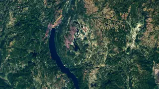
While browsing satellite images for a camping trip, an amateur astronomer noticed a circular depression in Quebec's Côte-Nord region. Follow-up research, including an expedition, confirmed it as a 25-kilometer-wide impact crater formed about 390 million years ago. The finding was verified by the presence of shatter cones, distinctive rock features caused by impact shock.
The discovery began with Joël Lapointe's 2024 satellite map review for a camping trip, when the circular depression near Lake Marsal caught his eye. His outreach to specialists led French researchers to flag the site as a potential impact structure at a Meteoritical Society meeting, which eventually drew Gordon Osinski's attention. Osinski's October 2025 expedition faced immediate obstacles—the floatplane couldn't reach shore, forcing the team to wade 50 meters through water before encountering swampy terrain and dense vegetation. On the second day, they found shatter cones in multiple outcrops, confirming the impact origin. The 25-kilometer-wide structure, with its central uplift and columnar jointing, now stands as Quebec's 11th confirmed impact crater.
The confirmation of a 25-kilometer impact crater could reshape understanding of Earth's impact history, suggesting that significant structures may still be hiding in remote regions. The discovery may encourage more systematic searches of satellite imagery by both amateurs and professionals, potentially accelerating the identification of other unknown craters. For the Côte-Nord region, the finding could draw scientific tourism and research interest, though the site's extreme remoteness may limit broader economic effects. The use of shatter cones as definitive field evidence reinforces the value of traditional geological verification alongside modern remote sensing.