Explosive Pacific storm: What fueled Hurricane Polo's rapid leap to Category 5
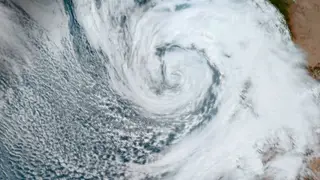
Hurricane Polo intensified from a tropical storm to a Category 5 hurricane in under 24 hours, reaching winds of 180 mph, before weakening slightly to Category 4. The rapid growth was driven by exceptionally warm Pacific waters linked to a strong El Niño, along with low wind shear and favorable upper-level conditions. Although not expected to make landfall, the storm threatens heavy rainfall and flooding along Mexico's southwest coast.
Hurricane Polo's explosive growth hinged on a rare convergence of oceanic and atmospheric conditions. Sea surface temperatures in the eastern tropical Pacific ran more than 2°C above normal—the threshold for a "super" El Niño—supplying the storm with exceptional heat and moisture. Simultaneously, weak wind shear and upper-level winds that allowed air to vent freely from the storm's top prevented disruption of its organizing thunderstorm activity.
The storm also developed a compact, well-defined core, which concentrated its energy into a tight radius and accelerated the intensification process. While rapid intensification occurs several times yearly across the globe, Polo's combination of extreme ocean warmth and favorable atmospheric dynamics produced one of the Pacific season's most formidable systems, now drifting northwest with heavy rain and hazardous surf threats for Mexico's coast.
Coastal communities in southwest Mexico could face life-threatening flooding and mudslides even without a direct landfall, as heavy rainfall and hazardous ocean conditions may disrupt daily life, infrastructure, and local economies dependent on fishing and tourism. The storm's rapid intensification also highlights how warming ocean conditions may make such explosive development more common, potentially straining emergency preparedness systems that have limited time to respond to fast-evolving threats.