Satellite Captures Autumn Cloud Layer Over Pacific Northwest
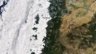
NASA's Terra satellite captured a low-lying cloud layer covering western Washington and Oregon on September 19, 2026, with mountain peaks rising above the fog. The marine stratus clouds formed when cool, moist air from the Pacific was trapped under a warmer layer, extending to the Cascade foothills. By afternoon, skies cleared over much of the region, though some clouds lingered along the Oregon coast.
The Terra satellite's MODIS instrument captured the scene at 10:45 a.m. local time, revealing a marine stratus layer that stretched inland to the Cascade foothills. The Olympic Mountains and Oregon Coast Range rose like islands above the fog. This phenomenon resulted from a temperature inversion, where cool, moist Pacific air became trapped beneath a warmer layer, causing water vapor to condense.
By the afternoon, the Aqua satellite observed significant clearing, though clouds lingered along the cooler Oregon coast. The event followed several nights of onshore flow, according to the National Weather Service. The image also showed smoke from wildland fires filling valleys in the North Cascades, adding a separate atmospheric feature to the scene.
This satellite imagery could enhance public understanding of regional weather patterns, particularly the marine layer that affects coastal communities. Forecasters may use such observations to improve predictions of fog and low clouds, which impact aviation, shipping, and morning commutes. The documentation of smoke from wildland fires alongside the clouds may also aid in air quality monitoring. For residents, the visual record offers a clear perspective on how atmospheric inversions shape local climate, potentially fostering greater appreciation for Earth observation technology.