NISAR Satellite Tracks Lava Flow in Kamchatka with Radar Time-Lapse
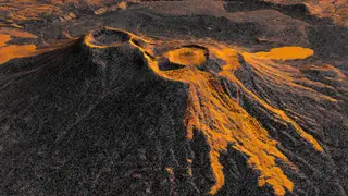
The NASA-ISRO NISAR satellite used radar to capture a time-lapse of lava spreading from Krasheninnikov volcano in Russia's Kamchatka Peninsula, which began erupting after a nearby earthquake. The satellite's repeated passes every 12 days allowed researchers to track the lava flow, highlighting its potential for monitoring natural hazards.
The eruption began just days after a magnitude 8.8 earthquake struck offshore, awakening a volcano dormant since roughly 1550. NISAR's L-band radar penetrates clouds and darkness, capturing surface changes at 10-meter resolution from 747 kilometers up. The satellite's dual-direction passes—one southbound, one northbound—every 12 days produced 17 usable frames spanning December 2025 through August 2026.
Radar imagery distinguishes lava from surrounding terrain because molten rock reflects microwave pulses more brightly than snow or bare ground. The time-lapse reveals lava filling an inner caldera, spilling into a wider crater, and spreading eastward in a fan shape. A separate northwest flow predates the satellite's first observation. The mission's near-global land coverage means similar monitoring could apply to other remote volcanoes lacking ground instruments.
The NISAR demonstration could reshape how remote hazards are monitored worldwide. Communities near volcanoes that lack ground-based instruments may gain earlier warning of eruptive activity, potentially aiding evacuation planning. The satellite's consistent 12-day revisit cycle could also support disaster response agencies tracking lava movement, ash deposition, or earthquake damage. However, its value depends on data processing speed and international data-sharing agreements, which may limit real-time applications in the near term.