Nolo intensifies south of Hawaii, raising flood concerns
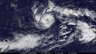
Hurricane Nolo is gaining strength south of Hawaii and may deliver severe flooding to the Big Island over the weekend. As of Friday morning, it had top sustained winds near 85 mph and was moving north-northeast. Forecasters expect further strengthening, possibly to major hurricane status, though its center should stay south of the main islands.
Nolo became a tropical storm on September 23, rapidly strengthened the next day, and attained hurricane strength that evening. By Friday morning UTC, it had 85 mph winds, Category 1 strength, and was about 220 miles south of South Point, tracking north-northeast at roughly 5 mph.
Forecasters expect further strengthening, possibly to major hurricane status, though the center should stay south of the main islands. Rainfall is the main concern: eastern and southern Big Island areas could get 15–30 inches, with peaks near 35; western Big Island up to 10; Maui up to 15; other islands 1–3, with maxima near 6. A 1–3 foot storm surge is possible in Hawaii County.
Residents and visitors on the Big Island and Maui could face disrupted travel, flooded roads, power outages, and dangerous surf, while emergency crews may be stretched by rescue and recovery needs. Farmers, outdoor workers, and tourism-dependent businesses may also see short-term losses. Because the storm’s center may remain offshore, the most likely societal strain could come from prolonged heavy rain, mudslides, and freshwater flooding rather than direct hurricane-force winds.