New Map Exposes Extensive Buried Valleys Beneath Greenland
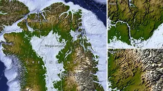
A NASA-led study has produced a more detailed map of the bedrock beneath Greenland's ice sheet. The mapping approach uses fine-scale satellite measurements of the ice surface to infer buried valleys and ridges, revealing a broad network that earlier maps missed or split apart. The findings add context to Greenland's geologic past and could help improve forecasts of how the ice sheet may change.
Greenland’s ice sheet covers about 1.7 million square kilometers and reaches over 3 kilometers thick, hiding bedrock never directly seen. The new approach, Ice Flow Perturbation Analysis, reads faint surface bumps and dips from fine-scale satellite measurements to infer buried valleys and ridges. Researchers manually mapped 1,943 subglacial valleys; roughly one-third were previously unidentified. About half of those in BedMachine Greenland now appear to reach farther inland, sometimes by hundreds of kilometers.
Many valleys start in southern and eastern highlands, where ice may have first formed. Near eastern highlands, the map shows a subglacial mountain range with alpine-style relief. In west-central Greenland, long, straight southwest-northeast valleys hint at tectonic control, though researchers call this pattern puzzling.
Better maps of Greenland’s hidden terrain could sharpen models of ice flow and future ice-sheet change. That may improve sea-level projections used by coastal planners, emergency managers, and communities in low-lying areas. Scientists studying glaciology and tectonics could also gain clearer context for Greenland’s geologic history. The benefits are likely indirect and uncertain, since mapping alone does not determine ice loss; it may reduce some uncertainty in risk assessments.