Satellite Imagery Documents Record-Breaking Hurricane Activity in Pacific Basin
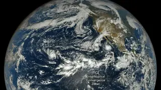
NASA's Earth-observing satellites captured imagery of an unusually active 2026 Pacific hurricane season, with twenty named storms and nine reaching hurricane strength by late September, significantly exceeding historical averages. Hurricanes Polo and Nolo were simultaneously impacting land across the Pacific basin, with Polo undergoing rapid intensification to category 5 status before making landfall in Baja California. The Intertropical Convergence Zone and exceptionally warm ocean temperatures have contributed to the elevated frequency and intensity of tropical cyclones across the northeastern and central Pacific regions.
The 2026 Pacific hurricane season has demonstrated significantly elevated storm activity compared to historical norms. Through late September, the region experienced nearly 50 percent more named storms than the typical average for the same period, with hurricane frequency also substantially above long-term baselines. Scientists attribute this surge to two primary factors: the Intertropical Convergence Zone's positioning and anomalously elevated ocean surface temperatures that provided ideal conditions for tropical cyclone development and intensification.
Hurricane Polo exemplified the extreme nature of the current season, undergoing a dramatic strengthening event that brought it to the highest storm category within days. The system's rapid weakening upon approaching land prevented the most severe potential impacts, though remnants continued affecting multiple regions across Mexico and the southwestern United States. Simultaneously, Hurricane Nolo impacted Hawaii, marking the third major hurricane to approach the islands during this season.
Record hurricane activity across the Pacific basin may affect coastal communities through intensified flooding, wind damage, and infrastructure disruption across Mexico, Hawaii, and the southwestern United States. Agricultural operations, tourism sectors, and emergency response systems in affected regions could face significant strain. Long-term implications may include increased pressure on disaster preparedness funding and climate adaptation planning, while elevated ocean temperatures could influence broader weather patterns affecting precipitation and seasonal forecasting for months ahead.