Understanding Tsunami Formation and Coastal Vulnerability Across Global Waters
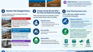
Tsunamis are series of long-period waves triggered by sudden seafloor displacement, typically from underwater earthquakes, that can travel across oceans at speeds exceeding 700 kilometers per hour while remaining nearly imperceptible in deep water. As these waves approach shallow coastal waters, their energy concentrates, causing wavelengths to shorten dramatically and wave heights to rise to dangerous levels potentially reaching several meters. The highest tsunami risks exist along subduction zones in the Pacific Ring of Fire and surrounding Indonesia, Japan, and South America, though the Mediterranean and Caribbean also face threats from seismic and volcanic events.
Tsunamis differ fundamentally from ordinary ocean waves because they involve movement through the entire water column rather than just surface disturbance. When triggered by seafloor displacement, these waves can cross vast ocean distances at remarkable speeds while remaining virtually undetectable in deep water. The danger emerges only as waves approach shore, where decreasing water depth forces energy to concentrate, transforming a barely noticeable swell into a towering wall of water capable of reaching several meters in height.
Geographic vulnerability varies significantly based on underlying geological structures. Subduction zones, where tectonic plates collide and accumulate immense stress before rupturing, pose the greatest risk and explain why the Pacific Ring of Fire and Indonesian waters experience disproportionately frequent tsunami events. Historical catastrophes demonstrate that even regions typically associated with lower risk, such as the Mediterranean and Caribbean, remain susceptible to devastating waves generated by earthquakes, landslides, or volcanic activity.
Understanding tsunami mechanics and risk geography could inform coastal planning and emergency preparedness policies affecting millions of residents in vulnerable regions worldwide. Communities in high-risk areas may benefit from improved early warning systems and evacuation infrastructure, while sea-level rise could potentially extend the inland reach of future events. The distinction between prevention and vulnerability reduction may shape how governments and organizations allocate resources for disaster mitigation and public safety initiatives in coastal zones.