Meteomatics drone reaches stratosphere to collect weather data
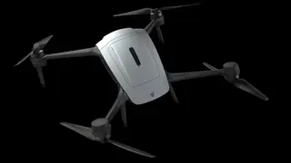
Swiss weather technology company Meteomatics has unveiled a multicopter drone that it says reached an altitude of 34,245 feet. The drone is designed to gather weather data from the stratosphere.
Meteomatics, a Swiss weather technology company, has introduced a multicopter drone. The company says it reached 34,245 feet. The craft is meant to collect weather observations from the stratosphere. This fits a wider interest in using drones for atmospheric monitoring, but the available information gives no details on sensors, endurance, or deployment.
If drones can reliably sample the stratosphere, meteorologists, aviation planners, and communities that depend on forecasts could gain more targeted observations. That may sharpen short-term modeling and risk preparation, though cost, airspace integration, and reliability would influence real-world benefits. The immediate societal effect is likely modest until independent verification and wider use occur.