How Waffle House's storm readiness became an informal disaster gauge
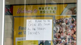
The Waffle House Index is an informal measure of storm damage based on whether local Waffle House restaurants remain open and what menu they can serve. A full menu signals minimal disruption, while a limited menu or closure suggests more severe conditions and greater need for aid. The chain's disaster preparedness and storm-center maps have made it a trusted reference for residents and federal officials in the Southeast.
The Waffle House Index is an informal gauge of storm severity based on whether a location remains open and what food it can provide. Green signals a complete menu and little disruption; yellow indicates a reduced selection, often with generator power or low supplies; red means the restaurant is shut and conditions are unsafe.
Craig Fugate reportedly devised the idea in 2004 while directing Florida’s emergency response after Hurricane Charley. He later used maps with color codes at FEMA. The chain, with over 1,900 mostly Southeastern sites, runs a storm operations hub and has long stressed preparedness.
The Waffle House Index may offer residents and emergency officials a familiar shorthand for storm disruption, potentially informing evacuation or aid decisions. It could also encourage other small businesses to consider continuity planning, since reopening quickly may build community trust and visibility. Still, relying on one chain’s locations may overlook areas without a nearby restaurant or with different needs.