NOAA Warns El Niño Could Match Record Strength by Late 2026
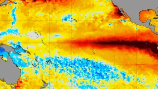
NOAA's Climate Prediction Center said on October 8 that the October–December Relative Oceanic Niño Index has an 83% chance of reaching at least +2.5°C. That threshold would surpass all El Niño events in the agency's record since 1950. The World Meteorological Organization separately projected a Niño-3.4 anomaly of about +3.7°C for the same period.
In September 2026, equatorial Pacific warmth intensified. NOAA’s CPC reported relative indices of +2.1°C in Niño-3.4, +3°C in Niño-3, and +3.9°C in Niño-1+2. Subsurface waters also ran far above normal, with eastern Pacific depth anomalies above +10°C. Westerly low-level winds, upper-level easterlies, and negative Southern Oscillation indices indicated ocean-atmosphere coupling.
CPC gave the three-month RONI at least +2.5°C probabilities of 54% for September–November, 83% for October–December, and 70% for November–January. That mark exceeds its “very strong” threshold of +2°C. WMO’s separate outlook used a different baseline and forecast near-certain persistence through February 2027.
If this forecast verifies, communities across the tropical Pacific and beyond may face heightened climate risks. Marine heatwaves could stress coral reefs and shift fisheries, affecting coastal livelihoods and food supplies. Some regions may see heavier rainfall and flooding, while others could experience drought, depending on El Niño’s teleconnections. Water managers, farmers, emergency planners, and public health officials may need to prepare for greater seasonal variability. Global weather patterns could also influence energy demand and commodity prices, though local outcomes remain uncertain.