Dead tree zones are spreading beyond US coasts to inland lakes
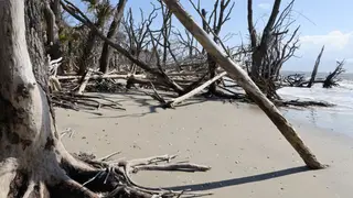
Using aerial imagery from 2012 to 2023, researchers mapped more than 260 million dead trees across US coastal and inland areas. Tree death tripled in low-lying coastal forests affected by salt and flooding, while mortality also doubled around expanding freshwater lakes and wetlands. The findings suggest climate-related water changes are reshaping forests far from the sea and may affect carbon storage.
Researchers examined aerial images collected from 2012 through 2023, covering areas within 10 kilometers of the Pacific, Atlantic, and Gulf coasts plus the Great Lakes shorelines. At roughly one-square-meter resolution, they recorded over 260 million dead trees, with over half of that loss occurring in only one-tenth of the surveyed forests.
The losses were not confined to salty coastal zones. Inland wetlands at higher elevations also showed die-offs. Coastal lowland mortality tripled where flooding and salt exposure overlapped, while deaths doubled near growing freshwater lakes and wetlands that received more rain. Record Great Lakes levels from 2013 to 2020 were linked to prolonged waterlogging.
The findings may affect forest managers, coastal and lakeside communities, and carbon accounting. If water-driven tree death expands, local ecosystems, timber resources, and recreation could change, while forests’ capacity to store carbon may decline. Scientists may need to include inland wetlands and lake shores in monitoring and restoration planning.