Satellite Images Reveal Extensive Flooding Across Thailand
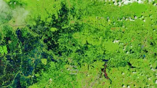
Persistent heavy rain from late September into early October 2026 caused sustained flooding in low-lying parts of Thailand. NASA Earth Observatory false-color images from Landsat 8 and 9 show floodwaters beside the Bang Pakong River and over agricultural or aquacultural land, including in Prachin Buri province. The flooding has affected millions of people across the country.
Thailand’s monsoon usually brings afternoon storms, but repeated rains from late September into early October 2026 left low-lying terrain flooded. Landsat 8 and 9 false-color views of Prachin Buri on October 2, 2026, compared with 2025, showed the Bang Pakong River beside inundated farms and aquaculture sites; red shapes were floating solar arrays.
A stalled low-pressure system, strengthened by the warm Gulf of Thailand, likely drove intense rainfall. Bangkok, about 100 kilometers west, got nearly 300 millimeters in 48 hours. Flooding reached 50 provinces, affected over 4 million people, and damaged roughly 270,000 hectares of farmland, including rice and orchards.
The flooding may disrupt daily life for millions, especially residents in low-lying communities and farmers whose rice fields and orchards