Masaya Volcano’s Underground Magma System Is Moving in Opposite Directions
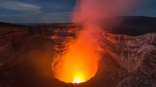
Satellite radar data from 2018 to 2024 show that Masaya volcano’s caldera first subsided and then rose, while ground around Santiago crater and its lava lake continued to sink. Researchers interpret this as different parts of the magma system changing independently, possibly with one reservoir inflating as another drains. The study in Geophysical Research Letters may help improve monitoring of hazards for the roughly 2 million people living nearby.
Masaya sits southeast of Managua, Nicaragua, within the Central American Volcanic Arc. Its activity stems from the Cocos Plate descending beneath the Caribbean Plate. Although its most recent large lava flow dates to 1772, the volcano still releases sulfur dioxide, sometimes at hazardous concentrations. About two million residents live within roughly 21 kilometers.
Researchers used Sentinel-1 radar images collected about every 12 days. By comparing returning microwave signals, they measured ground displacement through frequent cloud cover. From 2018 to 2024, the caldera floor first dropped and later uplifted, while land near Santiago crater and its lava lake kept subsiding. This pattern suggests separate magma storage zones may behave independently.
The findings may matter most to the roughly two million people living near Masaya, as better tracking of separate magma movements could sharpen hazard assessments and monitoring. Scientists studying basaltic volcanoes with lava lakes might also benefit from the approach. However, the study identifies no immediate danger, so any societal effect could depend on how such observations are integrated into longer-term warning systems and how future volcanic behavior unfolds.