Satellite View Shows Patchwork of Small Farms in Taiwan
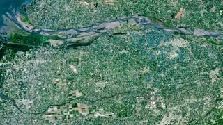
A satellite image reveals a colorful mosaic of tiny farm plots packed around Taiwan's largest river in Yunlin County. The county contains tens of thousands of size-restricted farms and supplies a majority of the island's food.
A satellite image captures a varied pattern of small agricultural plots gathered around Taiwan's largest river in Yunlin County. The county is home to tens of thousands of farms with size limits and produces most of the island's food. This view illustrates how spacecraft-based Earth observation can reveal details of farming landscapes and land use from orbit.
Satellite imagery of Yunlin County's farm patchwork could help farmers, planners, and food-supply observers better understand small-scale agriculture and local food production. It may raise public awareness of how land is used and how fragmented farms shape rural communities. Such views could support discussions about agricultural planning and resilience, though an image alone cannot determine policy or outcomes.