Satellite Altimetry Puts Current El Niño in Historical Context
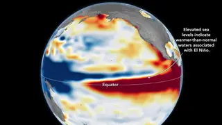
NASA Earth Observatory compared October 2026 sea-level patterns in the equatorial Pacific with those from October 1997. Both show elevated sea surface heights across the central and eastern equatorial Pacific, a characteristic El Niño signal. The comparison draws on a 35-year record from satellite altimetry missions including TOPEX/Poseidon, Jason-2, and Sentinel-6 Michael Freilich.
NASA Earth Observatory's comparison uses a 35-year satellite altimetry archive, spanning TOPEX/Poseidon, Jason-2, and Sentinel-6 Michael Freilich, to place October 2026 Pacific sea-level patterns beside October 1997. Elevated water heights across the central and eastern equatorial Pacific appear in both periods, a recognized El Niño signature.
El Niño arises from ocean-atmosphere feedback: weakened trade winds let warm western Pacific water move east, sometimes reversing winds and intensifying the cycle. Events occur roughly every two to seven years, but their location and atmospheric response vary, so no single typical pattern exists.
Comparing this El Niño with 1997 and 2015–16 may help emergency planners, farmers, water managers, and coastal communities anticipate possible drought, fire, crop failure, heavy rain, or flooding. Because each event differs in location and atmospheric response, forecasts could remain uncertain; early awareness may still support preparedness and resource allocation in affected regions.