Hurricane Polo weakens to Category 4 after rapid intensification
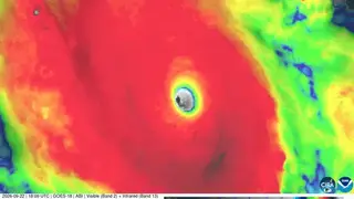
Hurricane Polo has dropped to Category 4 status as it moves northward along Mexico's southwestern coast, about 165 miles south of Zihuatanejo. The storm had explosively strengthened from a tropical storm to a Category 5 hurricane within a day, reaching winds of 180 mph and a record low pressure of 889 millibars. Warm waters from a super-charged El Niño contributed to its rapid development, though it is expected to remain offshore.
The storm's 889-millibar pressure reading places it among the most intense eastern Pacific hurricanes ever recorded, second only to the strongest on record. Its intensification rate ranks third in historical data, trailing Hurricane Patricia in 2015 and an unnamed 1957 storm. Hurricane Otis, which devastated Acapulco in 2023, intensified at a comparable pace, underscoring how unusual this rapid strengthening is.
Forecasters expect Polo to turn sharply northwestward by Wednesday and remain offshore through the week. However, coastal Guerrero and Michoacán could receive 4 to 8 inches of rain, with isolated totals reaching 12 inches, creating risks of life-threatening flooding and mudslides in steep terrain. Tropical storm-force winds, high waves, and rip currents will also affect the coastline.
Coastal communities in southwestern Mexico may face significant disruption even though the storm's center stays offshore. Heavy rainfall could trigger flooding and mudslides in vulnerable areas, threatening lives and property. Fishermen, tourism operators, and residents along the Guerrero and Michoacán coasts could experience economic losses from storm impacts. The storm's rapid intensification also highlights how warm ocean waters may produce increasingly dangerous hurricanes, potentially affecting emergency preparedness strategies in hurricane-prone regions.