New Mexico braces for days of heavy rain and flash flooding
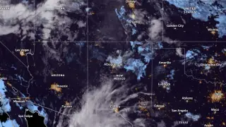
Flood Watches covered much of New Mexico on September 22, 2026, as tropical and monsoon moisture was expected to produce repeated heavy rain through at least September 24. The Weather Prediction Center placed southern New Mexico under a Moderate Risk of excessive rainfall, level 3 of 4. Flash flooding, river flooding, and debris flows near recent burn scars were possible.
Forecasters expect a prolonged stretch of stormy weather across New Mexico and nearby western Texas from Sept. 22 through at least Sept. 24. An upper-level trough, embedded disturbances, and deep tropical moisture are driving the setup, while a cool front moving in from the east may boost low-level convergence and upslope flow.
The Weather Prediction Center rated southern New Mexico at Moderate Risk—level 3 of 4—for excessive rain in the first 24 hours, then shifted that risk eastward. NWS Albuquerque projected 3–4 inches widely from Ruidoso and Roswell north toward Las Vegas, Roy, and Clayton, with isolated 5-inch totals possible and a lower chance of 6–8 inches in some areas.
Residents across much of New Mexico, especially in southern and eastern zones under flood watches, could face disrupted travel, rising rivers, and localized property damage. Communities near recent burn scars may be at greater risk from debris flows, while low-lying neighborhoods and those along the Rio Grande could see water enter roads or homes. Emergency responders and utilities may be strained by repeated storms, and residents may need to monitor alerts and avoid flooded routes.