Tropical Storm Nolo intensifies near Hawaii with extreme rainfall forecast
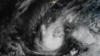
Tropical Storm Nolo strengthened south of Hawaii on September 24, 2026, with maximum sustained winds of 95 km/h. The Central Pacific Hurricane Center forecast 380–510 mm of rain across Hawaii Island, with localized totals near 890 mm. A Hurricane Watch was in effect for Hawaii County, and a Flood Watch covered Hawaii Island and Maui County.
Nolo's peak winds rose through Sept. 24, from 75 km/h early to 95 km/h by afternoon UTC, while its center sat about 460 km south of South Point and 735 km south-southeast of Honolulu. Its central pressure was estimated at 997 hPa, and tropical-storm-force winds reached roughly 150 km outward.
Forecasters expected rainbands to arrive on Hawaii Island later that day, hitting windward and southeastern areas hardest, with windward Maui also at risk. Nolo was projected to drift north or north-northeast, then turn sharply west near Hawaii Island by Sept. 26, possibly becoming a hurricane overnight and a major one over the weekend.
Residents, visitors, and workers across Hawaii Island and Maui County could face disrupted travel, closed schools and offices, and property damage if heavy rain and mudslides materialize. Coastal areas may see dangerous surf, rip currents, and possible surge, while emergency responders could be stretched by road closures and flood rescues. The storm's uncertain track means impacts may vary widely, so preparations and warnings may remain critical through the weekend.