Tropical cyclone moisture brings severe flood threat to southwestern U.S.
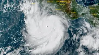
Hurricane Polo and the remnants of Tropical Storm Odalys are delivering tropical moisture to the interior southwestern United States, with 50-100 mm of rainfall expected across eastern Arizona, western New Mexico, and southwestern Colorado through September 30. The National Weather Service issued moderate risk excessive-rainfall outlooks covering much of Arizona and New Mexico with at least a 40% probability of flash flooding. The Little Colorado River is forecast to exceed flood stage at multiple locations, with the Holbrook gauge expected to rise to approximately 5.43 meters.
Two tropical weather systems are converging over the southwestern United States, creating a significant precipitation event. Hurricane Polo, situated near the Baja Peninsula with sustained winds near 185 km/h, is moving northeastward while interacting with remnants of Tropical Storm Odalys. A mid-latitude weather pattern—an eastward-moving shortwave trough—is channeling tropical moisture inland, where it will collide with atmospheric dynamics that force air upward and promote rainfall. Forecast models show considerable disagreement on precipitation totals, with European forecasts suggesting substantially higher rainfall than American models in key watersheds.
The Little Colorado River presents the most immediate hydrological concern, with water levels at Holbrook expected to rise from roughly 2 meters to over 5.4 meters—exceeding flood stage by nearly a meter. Some areas in northeastern Arizona and northwestern New Mexico could receive water equivalent to more than one-fifth of their typical annual precipitation in a single event. Eight stream gauges across the Four Corners region are forecast to either exceed flood stage or trigger action-level alerts.
This flood event could affect rural communities, agricultural operations, and infrastructure across Arizona, New Mexico, and Colorado. Flash flooding poses risks to persons in flood-prone areas and low-lying crossings, while sustained heavy rainfall may damage crops and livestock operations dependent on these watersheds. Emergency management agencies may face demands for rescue operations and recovery assistance. The uncertainty between competing forecast models compounds preparation challenges for regional water authorities and emergency responders.