Satellite Imagery Tracks Manitoba Farmland Through Growing Season in Remote Wetlands Region
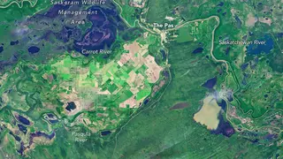
NASA's Landsat satellites captured images of the Carrot River Valley, Manitoba's northernmost agricultural area, showing the transition from summer growth to autumn harvest between July and September 2026. The 40,000-hectare farming region forms an isolated pocket of cultivated land surrounded by wetlands and marshes within the Saskatchewan River Delta. The satellite data demonstrates how remote sensing technology monitors seasonal changes in isolated agricultural communities.
The Carrot River Valley represents a unique agricultural pocket in Canada's northern interior. Spanning over 40,000 hectares within Manitoba's Rural Municipality of Kelsey, this farming region has defied the surrounding landscape of marshes and waterways that characterize the broader Saskatchewan River Delta. The area's agricultural viability depends heavily on infrastructure developed decades ago, including an extensive network of dikes and pumping systems implemented during the 1950s to manage seasonal water challenges.
The 2026 growing season documented by satellite data reveals the practical constraints of northern farming. Regional planting occurred later than southern areas due to excessive moisture, yet the combination of nutrient-rich soil and extended daylight hours enabled crops to mature within compressed timelines. By autumn, harvest progress reflected uneven precipitation patterns, with some zones completing half their wheat harvest while others remained weather-dependent.
Remote sensing technology enables agricultural monitoring in isolated communities where traditional field surveys prove logistically difficult. Farmers and regional planners may benefit from timely satellite data for crop assessments and resource management decisions. Climate variability in northern regions could pose increasing challenges to food production systems, potentially affecting both local economies and broader food security considerations for Canadian provinces dependent on these harvests.