Gulf Storm System Intensifies Into Hurricane Threat for U.S. Coast
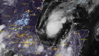
A tropical depression that formed in the Gulf of Mexico on October 6 is expected to strengthen into a hurricane by Thursday before reaching the U.S. northern Gulf Coast on Friday. The system poses significant risks including dangerous winds, storm surge, and heavy rainfall across Louisiana, Mississippi, and Florida. Residents in the affected region are being advised to prepare hurricane plans and monitor forecast updates closely.
The depression originated in the southwestern Gulf of Mexico on October 6 and is tracking eastward at a relatively slow pace. Forecasters anticipate a steady intensification process, with the system expected to reach tropical storm status by early Wednesday morning and hurricane-force winds by Thursday. Peak intensity is predicted at Category 2 strength, with maximum sustained winds around 155 km/h (100 mph), before wind shear conditions limit additional strengthening as it approaches the coastline.
Rainfall represents a significant concern for the region, with projections ranging from 75 to 150 mm across the central U.S. Gulf Coast, and some localized areas potentially receiving up to 250 mm. Storm surge and dangerous ocean conditions, including life-threatening rip currents and elevated swells, are anticipated to develop along affected coastlines by late week. The system's large size means impacts could extend considerably east of the center track.
The approaching hurricane could disrupt coastal communities across Louisiana, Mississippi, and Florida through multiple hazards simultaneously. Heavy rainfall may trigger urban and flash flooding, while storm surge and extreme winds could damage infrastructure, power systems, and property. Residents in the forecast path may face evacuation orders, temporary displacement, and significant recovery needs. The below-average forecast confidence adds uncertainty, potentially complicating emergency preparedness decisions for local authorities and residents making protection choices.