Curiosity Rover Photographs Windcarved Martian Formations in Unprecedented Detail
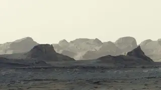
NASA's Curiosity rover captured its clearest images yet of yardangs—sharp, wind-sculpted ridges of sediment—on Mars on August 11, 2026, revealing features scientists have long sought to observe closely. The panoramic image, created from six combined photographs by the rover's Mastcam, shows the formations stretching approximately 10 miles along Mount Sharp's northwestern slopes and captures the distinctive blue hues of Martian dawn light. These geological features help astronomers understand Mars' past climate, as the layered mountain contains evidence of ancient lakes and streams that existed billions of years ago.
NASA's six-camera panorama reveals yardangs stretching across Mount Sharp's northwestern region, geological formations shaped by wind erosion over millions of years. The distinctive blue coloration visible in the unprocessed image reflects the unique atmospheric conditions during Martian dawn, providing scientists with visual data about how the planet's landscape has been sculpted by environmental forces. Mount Sharp's layered structure serves as a geological record, with each stratum representing different periods when liquid water flowed across Mars' surface before evaporating and leaving mineral deposits behind.
Project scientist Ashwin Vasavada notes the yardang layer appears anomalous—unusually colored and tilted—suggesting a volcanic origin, possibly from ancient ash falls. The rover is expected to reach these formations in 2027 for direct instrumental analysis, potentially resolving questions about their genesis that current imaging cannot definitively answer.
This discovery could enhance scientific understanding of Mars' climate history and geological processes, informing theories about planetary habitability and atmospheric evolution. The successful documentation may influence future rover mission planning and site selection for deeper investigation. Educational value could stimulate public interest in planetary science, potentially affecting funding discussions and recruitment for space exploration programs. The findings may also provide comparative insights into erosion patterns on Earth, benefiting geological research beyond Mars study.