Tropical Storm Isaias intensifying rapidly as it approaches U.S. Gulf Coast Friday
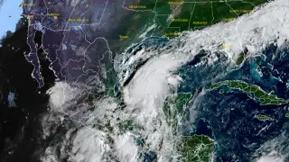
A tropical depression strengthened into Tropical Storm Isaias on October 7, 2026, over the Gulf of America and is forecast to become a hurricane by Thursday before making landfall on the northern U.S. Gulf Coast on Friday. The storm poses significant risks of dangerous winds, storm surge, and heavy rainfall across Louisiana, Florida, and the Southeast through the weekend. Residents along the affected coastline have been advised to finalize hurricane preparedness plans as watches are expected to be issued.
Tropical Storm Isaias emerged from a tropical depression on Wednesday morning and is undergoing a period of rapid intensification typical of systems over warm Gulf waters. The storm's trajectory will carry it across the Yucatan Peninsula before turning northward toward the U.S. coastline, with meteorologists anticipating it will reach hurricane status within 24 hours and potentially peak at Category 2 strength before weakening upon landfall.
Uncertainty remains regarding the precise path, as forecast models show notable disagreement about whether the system will track east or west across the Gulf. This divergence may affect which coastal communities face the most severe impacts from wind, storm surge, and rainfall before the system dissipates over the southeastern interior by early next week.
Tropical Storm Isaias could pose substantial risks to millions of residents and infrastructure across Louisiana, Mississippi, Alabama, Florida, and the broader Southeast. Potential impacts include dangerous coastal storm surge, widespread power outages from strong winds, and inland flooding from heavy precipitation. Businesses, transportation networks, and emergency services in the affected regions may experience significant disruptions, while vulnerable populations could face particular challenges during evacuation and recovery phases.