Isaias builds toward Gulf Coast landfall amid exceptionally warm sea temperatures
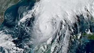
Hurricane Isaias strengthened into the first hurricane of the 2026 Atlantic season and reached Category 2 status as it moved northeast across the Gulf of Mexico. Hurricane warnings covered parts of Mississippi, Alabama, and the Florida Panhandle, with landfall expected near Pensacola late Friday or early Saturday. The storm rapidly intensified over Gulf waters that were the warmest on record for early October, and forecasters warned that dangerous storm surge would occur even if the hurricane weakened before reaching shore.
Isaias became the 2026 Atlantic season’s first hurricane on Wednesday night, arriving 57 days after the usual first-hurricane date and the latest since 1914. Its winds rose 40 mph in 24 hours, surpassing the 35-mph rapid-intensification threshold, and by Thursday afternoon it was a Category 2 storm with 100-mph winds.
At 5 p.m. EDT Thursday, Isaias lay about 325 miles south of the Mississippi River mouth, moving northeast at 12 mph over Gulf waters near 30–31°C—record-warm for early October. Hurricane warnings covered parts of Mississippi, Alabama, and the Florida Panhandle, with landfall expected near Pensacola and dangerous surge forecast from the Mississippi River mouth to Suwannee, Florida.
Coastal residents and businesses from Mississippi through Alabama and the Florida Panhandle, especially near Pensacola, may face dangerous storm surge, damaging winds, and disrupted travel or power. Even if Isaias weakens before landfall, surge flooding could still threaten homes, roads, and infrastructure, potentially straining emergency services and prompting evacuations. Communities with limited mobility, visitors, and outdoor workers could be especially exposed. Recovery and local economies may be affected if ports, beaches, or highways close.