Isaias intensifies before Gulf Coast landfall, tornado risk issued
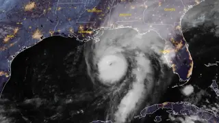
Hurricane Isaias strengthened to 110 mph on October 9, 2026, as it approached the northern Gulf Coast. The Storm Prediction Center warned that rainbands could spawn tornadoes across parts of Florida, Alabama, and Georgia. The storm was forecast to make landfall late Friday or early Saturday, bringing dangerous storm surge and winds.
The Storm Prediction Center placed portions of the Florida Panhandle, southeastern Alabama, and southwestern Georgia under a Slight Risk for severe thunderstorms. Rainbands from Isaias were expected to push inland during the afternoon, with tornado potential persisting overnight as the bands spread into Georgia.
At 09:00 UTC, Isaias packed 110 mph winds and a 963 hPa central pressure, moving north-northeast at 15 mph. Hurricane warnings stretched from Ocean Springs, Mississippi, to Florida’s Bay/Gulf County line, while surge warnings covered the Mississippi River mouth to the Suwannee River. Forecast rainfall reached 4–8 inches, with isolated 15-inch totals possible.
Residents, visitors, and responders across the northern Gulf Coast could face dangerous winds, storm surge, flooding, and possible tornadoes. Coastal communities may see property damage, power outages, and disrupted travel, while inland areas in Alabama and Georgia could deal with flash flooding and river rises. People in warning areas may need to finish preparations quickly and follow local guidance, especially those in low-lying areas. Recovery demands could strain local services, though impacts will depend on landfall timing, intensity, and tide.