Champi prompts typhoon and flood alerts across Mariana Islands
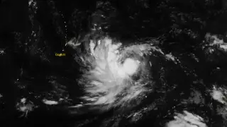
Tropical Storm Champi was tracking westward toward the Mariana Islands on October 16, 2026, with sustained winds near 65 km/h. Forecasters warned that it could strengthen into a typhoon by October 17 and pass near Guam the next morning, bringing damaging winds and heavy rain. Rainfall totals of 152–305 mm were possible, raising flood concerns in urban and low-lying areas of Guam, Rota, Tinian, and Saipan.
Champi strengthened from a tropical depression to a named storm, with maximum sustained winds around 65 km/h. At 01:00 ChST on October 16, its center sat roughly 1,330 km east of Guam and moved westward at 19 km/h. Typhoon and flood watches covered Guam, Rota, Tinian, and Saipan.
Forecasters expected further strengthening, possibly reaching typhoon status on October 17. A typhoon watch means sustained winds of at least 119 km/h are possible within 48 hours. Rainfall of 152–305 mm could trigger flooding, while seas might exceed 6.1 m during the closest approach.
Residents of Guam, Rota, Tinian, and Saipan could face disrupted travel, power, and daily routines as damaging winds, heavy rain, and coastal flooding approach. Low-lying and poorly drained neighborhoods may be especially vulnerable, while mariners and coastal communities could encounter dangerous seas. Emergency preparations and watches may help reduce risk, but uncertainty in the storm’s exact track means impacts could vary across the islands.