Oklahoma City area faces dangerous flash floods as Canadian River rises
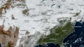
Thunderstorms produced 76–152 mm of rain across the Oklahoma City metropolitan area on October 14, 2026, with radar indicating 102–279 mm farther west. The National Weather Service described the flash flooding as life-threatening and warned that creeks, streams, roads, underpasses, and urban areas could flood. Major flooding was forecast on the Canadian River near Bridgeport, and a Moderate Risk of excessive rainfall remained for parts of Oklahoma and the Red River Valley of Texas through 12:00 UTC on October 15.
On October 14, 2026, storms dropped 3–6 inches across the Oklahoma City metro, while radar showed 4–11 inches west. Norman's weather office called the flood threat dangerous to life and warned that waterways, roads, underpasses, and cities could be affected. Warnings covered Oklahoma County and nearby counties, later expanding east and southeast.
The Canadian River near Bridgeport was expected to reach major flood stage, with moderate flooding already underway. Forecasters linked the event to an upper low, a front, and deep Gulf and eastern Pacific moisture; Norman recorded its highest October precipitable water value. Hurricane Simon also added moisture.
Residents across the Oklahoma City metro and western Oklahoma could face disrupted travel, flooded homes, and dangerous road conditions as waterways rise. Drivers may encounter closed underpasses and submerged streets, while rural communities and agricultural or oil operations near the Canadian River could be isolated or damaged. Emergency responders may be stretched by multiple warnings, and recovery could take time if major flooding occurs. The situation remains hazardous through the forecast period.