Polo Strengthens to Category 5, Marking Rare Triple in Pacific Season
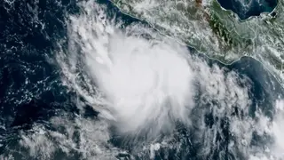
Hurricane Polo has intensified to Category 5 with maximum sustained winds of 160 mph, making it the third Category 5 hurricane in the eastern or central Pacific this season. The storm is moving slowly off Mexico's coast, with a tropical storm watch in effect from Tecpan de Galeana to Manzanillo. Coastal areas of Guerrero and Michoacán could see up to 8 inches of rain.
Polo's rapid intensification to Category 5 ties the season with only three prior years (1994, 2002, 2018) that produced three such storms in the eastern/central Pacific. The storm's forward motion is exceptionally slow, around 5 mph, prolonging exposure to warm coastal waters and raising rainfall potential. Forecasts indicate a sharp northwestward turn, but the slow drift means coastal watches may soon become warnings.
The article highlights a stark hemispheric contrast driven by El Niño. While Atlantic storm Fay quickly weakened, Polo thrives over record-warm sea surface temperatures. Climate Central's analysis suggests human-induced climate change made ocean temperatures along Fay's path 100 to 200 times more likely, underscoring background warming's role. Polo's potential to reach or exceed Category 5 midweek poses a direct threat to Mexico's Pacific coast.
The slow-moving storm could bring severe flooding and mudslides to coastal Guerrero and Michoacán, affecting thousands of residents and disrupting local economies reliant on fishing and tourism. The rare triple Category 5 season may heighten public concern about climate change's influence on storm intensity, potentially prompting stricter building codes or evacuation planning. Additionally, the stark Atlantic-Pacific contrast could reshape seasonal forecasts and insurance risk assessments, though such effects remain speculative.