Hurricane Polo rapidly intensifies to Category 5 off Mexico's Pacific coast
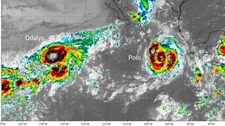
Hurricane Polo underwent extreme rapid intensification, reaching Category 5 with winds of 180 mph and a central pressure of 892 mb, the second lowest on record in the eastern Pacific. It has since weakened slightly to a strong Category 4, with tropical storm warnings in effect along Mexico's coast from Lázaro Cárdenas to Punta San Telmo. The storm is expected to bring up to eight inches of rain and waves of 46 feet, with a slow movement and an unusual northwest turn.
Polo's explosive development saw its central pressure plummet to 892 mb, a figure surpassed only by Hurricane Patricia's 872 mb in 2015. The storm's unusually compact core and double eyewall structure facilitated this rapid spin-up, though it has since expanded and weakened to a strong Category 4. Its forward speed has been remarkably slow, nearly stationary Wednesday, which typically would upwell cooler water, but exceptionally deep warm water—exceeding 30°C at 60 meters—fueled by El Niño and long-term warming, has sustained it. Forecasts keep Polo parallel to Mexico's coast, maintaining major-hurricane status into the weekend before approaching Baja California.
Coastal communities from Michoacán to Jalisco face immediate threats from torrential rain, 46-foot waves, and potential storm surge, which could trigger flooding and landslides. The slow, erratic track may prolong hazardous conditions, disrupting shipping, fishing, and tourism. As a major hurricane lingering near populated coastlines, Polo could strain emergency services and force evacuations, while its unusual northwest turn raises uncertainty for Baja California later. The storm's intensity, tied to record-warm ocean heat, may serve as a stark example of how climate change amplifies extreme weather risks for vulnerable coastal populations.