Polo bears down on Baja California while Northeast endures drawn-out coastal storm
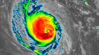
Hurricane Polo is bearing down on Mexico’s Baja California peninsula, with hurricane warnings issued for much of the region and additional alerts added along the mainland coast. After fluctuating between Category 4 and 5 strength offshore, Polo was a Category 3 storm with 125 mph winds on Sunday and was forecast to make landfall Monday afternoon near Las Barrancas. Meanwhile, an unusually long-lasting coastal storm was affecting the northeastern United States and New England.
Polo spent days offshore fluctuating between Category 4 and 5 before weakening to Category 3 with 125 mph winds Sunday. It was expected to strike Baja California Sur Monday afternoon near Las Barrancas, with warnings later extended across the Gulf of California to mainland areas from Guaymas to Huatabampito.
Forecasters warned of 4–8 inches of rain, locally 12, over central Baja California Sur and lesser amounts in southern Sonora, raising flood and mudslide risks. Tropical Depression 18E became Tropical Storm Rachel and could become a hurricane, though it was projected to remain offshore.
Hurricane Polo could disrupt daily life across Baja California Sur and nearby mainland communities, with flooding, mudslides, dangerous surf and power outages possible. Residents, tourists and emergency crews may face hazardous travel and property damage. In the U.S. Northeast, the slow coastal storm may prolong beach erosion, travel delays and flood risks. Later, remnant moisture could bring heavy rain to the Southwest and Central states, affecting roads and water management.