Hurricane Polo reaches Category 5 again, menacing Mexico and Hawaii
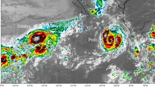
Hurricane Polo has re-intensified to Category 5 with top winds of 160 mph, after earlier fluctuating between Categories 4 and 5. Tropical storm warnings are in effect from Tecpan de Galeana to Manzanillo, Mexico, and the storm is forecast to parallel the coast and approach Baja California by Monday. Meanwhile, another tropical system threatens eastern Hawaii with dangerous surf and rainfall of 10 to 30-plus inches.
Polo’s minimum central pressure of 892 mb ranks as the second-lowest ever recorded in the eastern Pacific, trailing only Hurricane Patricia’s 872 mb. Its wind speed jumped 110 mph in 24 hours, marking the fifth-fastest intensification in NOAA’s satellite record. The storm’s compact core, which has displayed a double-eyewall structure, is now expanding as it matures.
The hurricane is nearly stationary but is forecast to drift west-northwest, paralleling Mexico’s coast and potentially reaching Baja California by Monday. Warnings currently cover the entire coastline of Michoacán state. Separately, another tropical system threatens eastern Hawaii with dangerous surf and rainfall of 10 to 30-plus inches.
Coastal communities in Mexico and Hawaii face significant risks from Polo and the separate Hawaii system. Storm surge, destructive winds, and torrential rain could damage homes, disrupt transportation, and threaten tourism and fishing livelihoods. The storm’s slow movement may prolong exposure to hazards. The record El Niño and ocean warming suggest such extreme rapid intensification events could become more frequent, increasing preparedness challenges for vulnerable populations.