Explosive Hurricane Polo Hits Category 5 as It Drifts Near Mexico
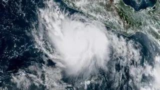
Polo reached Category 5 status early Tuesday, with winds of 160 mph, becoming the third such storm in the Pacific this year. It is forecast to hold major hurricane strength through the weekend while drifting near Mexico. Heavy rainfall of up to 8 inches is possible along the coast from Guerrero to Colima.
Polo's rapid intensification places it in rare company, as only three prior seasons on record produced three Category 5 hurricanes across the eastern or central Pacific. The storm's slow forward motion near the Mexican coastline heightens the risk of prolonged heavy rainfall, with isolated totals approaching 8 inches possible across Guerrero and Michoacán.
The storm's development is tied to an active El Niño, which has also suppressed Atlantic activity. Tropical Storm Fay, which briefly organized over unusually warm North Atlantic waters, weakened quickly. Climate Central's analysis indicates human-caused warming made ocean temperatures along Fay's path dramatically more likely.
Polo's proximity to the Mexican coast could affect coastal communities from Guerrero to Colima, with tropical-storm-force winds and heavy rainfall threatening vulnerable areas. Residents and emergency services may face challenges from flooding and storm surge, while the slow-moving storm could prolong hazardous conditions. The record-breaking Pacific season may also strain disaster-response resources and heighten awareness of climate-related weather extremes.