Category 3 hurricane strikes Baja California peninsula with life-threatening conditions
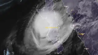
Hurricane Polo made landfall on the west coast of Baja California Sur with maximum sustained winds of 175 km/h and a minimum central pressure of 965 hPa, with hurricane-force winds extending 65 km from the center. The system was forecast to cross the peninsula and make a second landfall in southern Sonora, with anticipated rainfall of 150-305 mm across parts of Baja California Sur and 100-200 mm in Sonora, creating risks of life-threatening flooding and mudslides. Large and destructive waves and significant coastal flooding were expected in areas exposed to onshore winds.
Hurricane Polo struck Mexico's western coast as a powerful Category 3 system, with its center positioned between two coastal towns in Baja California Sur. The storm maintained hurricane-strength conditions across the peninsula's width, with destructive winds and precipitation bands affecting a broad area. Forecasters anticipated the system would retain tropical cyclone status for a second strike on mainland Sonora before terrain and atmospheric conditions caused rapid deterioration.
Communities in the path faced compounding hazards. Beyond wind damage, the projected rainfall amounts—potentially exceeding 300 millimeters in some locations—created significant flood and mudslide risks, particularly in elevated areas. Infrastructure vulnerability became apparent when electrical failures disrupted water service in populated areas, complicating emergency response and basic needs provision during active weather conditions.
The hurricane's dual landfall and cross-peninsula transit could affect thousands of residents and infrastructure across two Mexican states. Coastal populations face immediate risks from storm surge, wave action, and wind damage to structures and utilities. Inland communities may experience prolonged disruption from flooding and mudslides affecting transportation, water systems, and emergency services. Agricultural areas and tourism-dependent economies could suffer significant losses. The system's potential to influence weather across the southwestern United States suggests broader regional impacts on weather patterns in the coming days.