Major hurricane approaches Mexico with dual-landfall scenario predicted
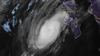
Category 3 Hurricane Polo was positioned 175 km southwest of Cabo San Lázaro on September 28 with maximum sustained winds of 185 km/h and a central pressure of 958 hPa, moving north-northeast at 17 km/h toward Baja California Sur. Hurricane warnings covered sections of both coasts of the peninsula and mainland Sonora, with the system forecast to make landfall in Baja California Sur late September 28 before reaching southern Sonora as a hurricane. Rainfall of 150-305 mm was expected across Baja California Sur, with 100-200 mm anticipated in Sonora, presenting risks of life-threatening flooding and mudslides in steep terrain.
Hurricane Polo presented a particularly challenging scenario for Mexico's northwestern coast due to its forecast path crossing the Baja California Peninsula before re-emerging over water. The system's dual-landfall trajectory meant that affected regions would experience two distinct periods of severe weather rather than a single impact, complicating evacuation and response efforts. The hurricane's northeastward movement, steered by atmospheric pressure systems over Mexico and California, positioned it to maintain near-major-hurricane intensity through its initial strike on Baja California Sur.
The anticipated rainfall posed significant hazards beyond wind damage, with some areas potentially receiving over 300 millimeters of precipitation in short timeframes. Sonora's mountainous terrain particularly increased vulnerability to cascading hydrological hazards, as saturated slopes become prone to rapid mass movements. Regional authorities preemptively suspended economic and educational activities while establishing coordination centers to manage the multi-day emergency response.
Hurricane Polo's dual-landfall forecast could disrupt critical infrastructure, livelihoods, and public safety across two Mexican states simultaneously. Coastal communities face threats from storm surge and destructive waves, while inland populations in steep terrain could experience severe flooding and mudslides affecting water supplies and transportation networks. The suspension of maritime activities and government operations may strain emergency resource distribution and economic activity. Vulnerable populations with limited shelter access could face extended displacement if storm impacts exceed current shelter capacity estimates.