Tropical Storm Isaias Set to Become Latest-on-Record First Atlantic Hurricane
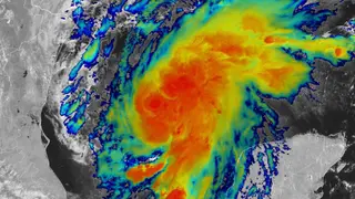
Tropical Storm Isaias is forecast to strengthen into the first Atlantic hurricane of an unusually delayed season by early Thursday before making landfall on the U.S. Gulf Coast Friday night or Saturday morning. The storm could peak as a major Category 3 hurricane, with significant storm surge impacts expected regardless of any last-minute weakening. Record-warm Gulf water temperatures, exacerbated by human-caused climate warming, are fueling the system's rapid intensification.
Tropical Storm Isaias represents a historic meteorological event: it will become the first Atlantic hurricane of a season that has experienced an unusually extended delay. Water temperatures in the Gulf of Mexico are setting records for early October, averaging between 86-88 degrees Fahrenheit along the storm's path. These exceptionally warm conditions are driving the system's rapid intensification despite moderate wind shear, with atmospheric moisture levels also supporting organizational development.
Multiple forecast models diverge on final positioning, with some predicting a strike near the Mississippi coast while others favor the western Florida Panhandle. The discrepancy reflects ongoing uncertainty in storm intensity and forward speed, though the general track consensus points toward the central Gulf Coast. Weakening before landfall could reduce wind damage, but surge impacts appear likely regardless of last-minute intensity changes.
Residents across Louisiana's coast through the Florida Panhandle face potential evacuation and property damage from both storm surge and winds. The variance in model forecasts creates additional planning challenges for emergency management officials and residents attempting to prepare. Economic impacts could extend beyond immediate coastal zones to inland communities affected by flooding. Record-warm Gulf waters—linked to long-term climate patterns—may influence how intensely coastal regions experience such storms in coming decades.