Tropical Storm Rachel Raises Flood Risk Across Southern California and the Southwest
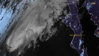
Tropical Storm Rachel was moving northeast over the eastern Pacific on October 10, 2026, with sustained winds of 95 km/h and a central pressure of 990 hPa. Forecasters expect it to near northern Baja California or Southern California late that day or early October 11, bringing heavy rain, flash flooding, strong winds, dangerous surf and coastal flooding. The Weather Prediction Center has marked parts of Southern California, northwestern Arizona, southern Nevada and southwestern Utah at Moderate Risk for excessive rainfall.
Rachel was centered roughly 1,080 km south-southwest of San Diego late on October 9 local time, packing 95 km/h winds and a 990 hPa core. It was advancing northeast at 19 km/h, with forecasts calling for faster forward motion and a possible approach near northern Baja California or Southern California before weakening inland.
The Weather Prediction Center placed parts of Southern California, northwestern Arizona, southern Nevada and southwestern Utah at Moderate Risk for excessive rainfall. San Diego County saw a rare tropical storm watch, only its second, after Hurricane Hilary in 2023. Rainfall forecasts ranged from 25–76 mm widely, with isolated 127 mm totals.
Residents and travelers across Southern California, northwestern Arizona, southern Nevada, southwestern Utah and northern Baja California could face flooded roads, flight and transit delays, and dangerous coastal conditions. People in mountainous and low-lying areas may be at greater risk from rapid runoff. Strong winds could disrupt power and travel, while emergency responders may need to manage water rescues and road closures. The storm’s main societal effect may depend on how quickly it weakens inland and where the heaviest rain falls.