Hurricane Polo's outer bands drench Mexico's coast, Baja California in forecast path
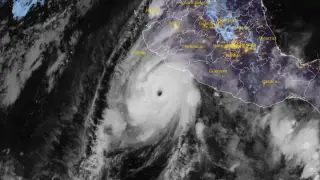
Hurricane Polo's outer rainbands brought heavy rain to southwestern Mexico on September 24, with a Tropical Storm Warning from Tecpan de Galeana to Manzanillo. The Category 5 hurricane remained offshore, but rainfall could cause life-threatening flooding and mudslides. Polo is forecast to approach the Baja California Peninsula as a hurricane early next week.
Polo’s core remained far offshore, yet its outer bands delivered significant rainfall—up to 8 inches in isolated spots of Guerrero. The storm’s central pressure was 923 hPa, with winds of 160 mph. A tropical storm warning stretched from Tecpan de Galeana to Manzanillo, with a watch extending further west.
The hurricane’s path is influenced by a high-pressure ridge, steering it northwest then north. Forecasters expect gradual weakening from wind shear, but Polo may still strike Baja California Sur as a hurricane early next week. Dangerous swells and rip currents are anticipated along the coast through the weekend.
Coastal residents and tourists in southwestern Mexico face immediate threats from flooding and mudslides, while those in Baja California Sur have several days to prepare. The storm’s slow movement could prolong hazardous surf and coastal erosion. Economic impacts may include disrupted shipping, fishing, and tourism. However, the forecast weakening and offshore track could limit the worst effects, though preparedness remains critical for vulnerable communities.