Watches issued across northern Gulf Coast as Tropical Storm Isaias gains strength
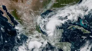
On October 7, 2026, forecasters issued hurricane, tropical storm, and storm surge watches for parts of the U.S. northern Gulf Coast as Tropical Storm Isaias intensified over the Gulf of America. A hurricane watch covered Bay St. Louis, Mississippi, to Indian Pass, Florida, while separate tropical storm watches applied to areas west and east of that stretch. The storm surge watch extended from the Mississippi River mouth to Yankeetown, with possible inundation of 1.5 to 2.1 meters in some locations if peak surge coincided with high tide.
EXPANDED:
Forecasters placed hurricane, tropical storm, and storm surge watches along the northern Gulf Coast on October 7, 2026, as Isaias strengthened. A hurricane watch stretched from Bay St. Louis, Mississippi, to Indian Pass, Florida, with possible hurricane conditions starting late Friday. Tropical storm watches covered areas to the west and east, where tropical storm conditions could arrive around midday Friday.
The surge watch ran from the Mississippi River mouth to Yankeetown. If peak surge matched high tide, water might rise 1.5–2.1 meters from Ocean Springs to Indian Pass and inside Mobile Bay, with lower amounts elsewhere. Isaias had 75 km/h winds and a 1,000 hPa