West Texas faces continued flood threat as heavy rain persists
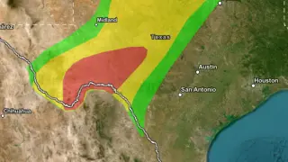
Parts of West Texas experienced flash flooding on October 15, 2026, after some locations received more than 127 mm of rain. The NOAA Weather Prediction Center kept a Moderate Risk of excessive rainfall for the region through 12:00 UTC on October 16. Additional thunderstorms were expected as a cold front interacted with moist air over the Southern Plains.
West Texas flooding on Oct. 15, 2026, followed rainfall that topped 127 mm in places. The Weather Prediction Center kept a Moderate Risk—its second-highest excessive-rainfall level—for the region until 12:00 UTC Oct. 16. A cold front moving south was expected to meet deep moisture over the Southern Plains, keeping thunderstorms and flood risks active.
Lubbock-area flash flooding was reported by the public, prompting a warning for central Lubbock County and northwestern Crosby County. Midland/Odessa also warned parts of Brewster and Terrell counties. Texas activated swift-water teams, boats, helicopters, medical crews, and infrastructure monitors ahead of the heaviest rain.
The continued flood threat could disrupt travel and daily routines for residents across West Texas, especially in Lubbock and nearby counties, where road closures and rising water may affect motorists. Emergency crews and local services may face added strain as they monitor waterways and respond to calls. If storms persist, some households and businesses could see property damage or temporary isolation, though the full extent may depend on how quickly conditions ease.